About Us
Tripura: At a Glance
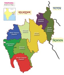
Tripura is a state in North-East India. It shares borders with Bangladesh, Mizoram and Assam. Tripura is surrounded by Bangladesh on its north, south and west. The length of its international border is 856 km (84 per cent of its total border). The state is connected with the rest of India by National Highway-8 links Guwahati to Sabroom via Agartala; being upgraded to 4 lanes.
| Particulars | Description |
|---|---|
| Area | 10, 491.69 sq.km. |
| Population | 36,73,917 (as per Census 2011) |
| Capital | Agartala |
| Official Languages | Bengali, Kokborok and English |
| Other Languages | Mogh, Chakma, Halam, Garo, Bishnupriya Manipuri, Manipuri, Hindi, Oriya etc. |
| Altitude | 12.80 meters |
| Temperature | Summer : 20° to 36° C. Winter : 7° to 27° C. Winter: 2°C Min |
| Rainy Season | June to September |
| Average Rainfall | 2500mm per annum |
| Highest Rainfall | 2855mm (Kamalpur) |
| Lowest Rainfall | 1811mm (Sonamura) |
| Literacy Rate | 87.2% (as recorded in 2011 Census). |
For further information navigate to :
- Back to previous page
- |
-
Page last updated date : 17-11-2025 02:51 PM

